Detail Gps X90 GNSS Specifications
Product Name : X90 GNSS RTK
Item Code : 42033654
Category: Navigation & GPS
Keywords : gps, GPS, GPS
Type: Gps Navigator
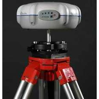
The CHC X90 is the GNSS survey solution selected by large number of surveyors for its outstanding performances and reliability. Its is a powerful and cost effective GNSS receiver designed for every day field works.
RTK Performances
The X90 offers greater performances with GNSS functionality. The GPS+ GLONASS feature increases availability in obstructed sky conditions such as construction sites in urban areas while securing RTK accuracy and fast initialization. Its optimized power management allows half day of non-stop RTK work with a single battery.
Cable Free
Built-in GNSS engine, antenna, Bluetooth communication and optional UHF and GSM/ GPRS modules in one single unit. The X90 base station can integrate a 1W internal UHF transmitter for an easy deployment in most construction sites.
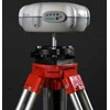
Compact and lightweight
The size of 20cm 8.5cm makes the X90 only weight 1, 4 kg. It significantly reduces tiredness of the surveyors in the field work.
Competitive and Reliable
The X90 GNSS is the first-choice solution for GPS+ GLONASS RTK
surveying at fraction of cost.
GNSS characteristic
54 channels :
� GPS : 14x L1, 14x L2
� GLONASS: 12x L1, 12x L2
� 2x SBAS ( WAAS, EGNOS, MSAS)
Advanced multipath mitigation
Optimized tracking for low signal strength
Performance specifications ( 1)
Real Time Kinematics ( RTK)
� Horizontal: 10mm+ 1ppm RMS
� Vertical: 20mm+ 1ppm RMS
� Initialization time: 10s
� Initialization reliability: typical > 99.9%
Post Processing Static
� Horizontal: 5mm+ 1ppm RMS
� Vertical: 10mm+ 2ppm RMS
Communications
1 RS232 serial port
1 high-speed USB
Optional GSM/ GPRS modem
Integrated Bluetooth communications port
Optional radio modem
� CHC DL3 : 1W 20W adjustable ( 2)
� Bandwidth: 450 470 MHz
� Pacific Crest : 1W internal ( Optional)
Protocols
� RTCM2.1, RTCM2.3, RTCM3.0, CMR and
RTCA input and output
� NMEA0183 output
� RINEX and HCN outputs for GPS raw data
Physical
Size ( H D) : 85mm 200mm
Weight: 1.4 Kg without battery Working Temperature: -30 C to + 65 C Storage Temperature: -40 C to + 75 C ? Humidity: 100% condensation
Dustproof: IP67
Waterproof : protected from temporary immersion to depth of 1 meter, floating.
Shock : survive a 2 meters drop onto concrete
Electrical
Typical power consumption: 2.8W
Battery capacity : 2400mAh
Operating times on internal battery : 6 hours ( Static) ,
4.5 hours( RTK)
External power input : 9-18VDC
Software
Optional Landstar field software
� Intuitive and easy to use data field survey soft- ware ( logging, stake-out, site calibration, ? )
Optional SurvCe field software
� Complete data collection solution for RTK GPS
and Total Stations ( optional)
� Combines advanced functionality and ease-of- use.
( 1) Accuracy, TTFF and reliability specifications may be affected by multi path, satellite geometry and atmospheric conditions. Performances assume minimum of 5 satellites and follow up of recommended survey practices.
( 2) UHF type approvals are country specific
Specifications are subject to change without notice.
Tampilkan Lebih Banyak